Fire Mitigation Diagrams
Click on a diagram for a larger image:
To remove living trees you must apply with the Architectural Control Committee. For information go HERE. Removing slash, fallen trees, and standing dead trees do not require an ACC application.
Harden Your Home | YouTube Video
Home Evaluation for Fire Mitigation
If you have questions or would like a home evaluation please contact :
Additional Information:
Information from the Colorado State Forest Service on how to protect your home: http://csfs.colostate.edu/pages/wf-protection.html
Here's a link to a Denver Post article that covers the material in an engaging way. Check out the additional links at the end of the article.
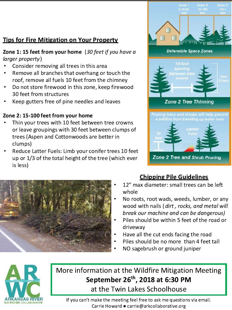
Create Defensible Space
Clean pine needles, leaves and other debris from roofs and gutter...
at least twice a year. This eliminates an ignition source for firebrands, especially during hot, dry weather.
Stack firewood away from your house.
Locate firewood at least 30 feet uphill from your home. Do not stack firewood under the deck.
Remove unhealthy vegetation.
Trees and shrubs that are stressed, diseased, dead or dying should be removed so that they do not become a fuel source for potential fires.
Create defensible space at a minimum of 100 feet around a home.
Increase this distance if the structure is located on a slope. See the linked information defining this.
Thin out continuous tree and brush (shrub) cover around structures.
Remove flammable vegetation from within the initial 15 feet around structures. To remove living trees you must apply with the Architectural Control Committee. For information go HERE.
Thin trees, beyond the initial 15-30 feet, to achieve a 10-foot crown spacing.
Occasionally, clumps of two or three trees are acceptable for a more natural appearance, if additional space surrounds them.
To remove living trees you must apply with the Architectural Control Committee. For information go HERE.
Mow grasses and weeds...
to a height of six inches or less for a distance of 30 feet from all structures.
Prune tree branches...
within the defensible space up to a height of 10 feet above ground.
Dispose of all slash and debris...
left from thinning by chipping, hauling away or piling for burning later. Always contact your county sheriff's office or local fire department first for information about burning slash piles. Contact your local CSFS district for information regarding chipping and other removal options.
Beneath large trees...
remove shrubs and small trees or other potential ladder fuels. Left in place, these fuels can carry a ground fire into tree crowns.
Trim any branches extending over roofs...
and remove branches within 10 feet of chimneys.
Stack firewood and woodpiles at least 30 feet...
from any structure. Make sure they are uphill or on the same level as structures, and clear away flammable vegetation from within 10 feet of these woodpiles.
Place liquefied petroleum gas (LPG)...
containers at least 30 feet from structures. Clear anything flammable, including vegetation from within 10 feet of all tanks.
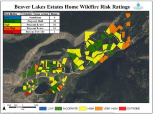
About the 2016 Wildfire Risk Assessment program
Firefighters from Leadville/Lake County Fire and Rescue have prepared maps to show them where houses are located and what the wildfire risk is to those structures. During a wildfire event this map would provide a “picture” of what the firefighters will encounter and serve as a planning aid to effectively allocate limited firefighting resources while providing for safety.
A fire-risk assessments on homes in Beaver Lakes Estates was completed in 2016 There was no cost to the homeowners. This program was funded by Colorado Water Conservancy Board grant dollars awarded to Lake County Fire and Rescue. Click on map for larger image.
Below is the approach to fire mitigation in subdivisions in order to meet the needs of both the homeowners and the Lake County firefighting community. Below are the steps that will be followed:
Step 1 – Evaluation- A trained fire mitigation specialist with wildland fire experience will visit the property and do a quick walk around the house and out buildings to assess the risk of the house catching fire during a moderate wildfire event. As part of the evaluation they will look at home construction, vegetation next to the home, the surrounding vegetation, and other variables.
Step 2 – Sharing Information- After the evaluation is completed, we will share the results of the assessments with the homeowner so they can better understand their wildfire risk.
Step 3 - Consultation – After the assessment is complete we will invite the homeowner to set up a free site visit with our fire mitigation specialist to discuss the results, answer questions, and explain what the homeowner can do to reduce their wildfire risk. If the homeowner wants assistance in creating or improving the defensible space around their home, the homeowner can sign-up to be part of a chipping program and or participate in being an applicant for a future fuels reduction grant to help defray the costs of work done.
Step 4 – Mapping – Leadville Lake County Fire will create a digital, printable map, that will show the location of the homes with the associated risk ratings. The map will be shared with the residents of Beaver Lake Estates as well as Lake County Fire and Rescue, Salida Fire, South Arkansas Fire Protection District, Chaffee County Fire Protection District, USFS, and other emergency responder agencies.
Step 5 – Updating Map – After the map has been created if a homeowner does work to reduce their risk they can contact our office and we will do a new evaluation and update the map accordingly.\